苏花高速
4A地址: 暂无
开放时间: 暂无


景点印象
好美的地方,山的样子好特别,隧道很多,甚至有些还是很古早的隧道,觉得前人很伟大,又刚好赶上了日出,在苏澳港上方看日出,一切都超美的
专门安排走苏花公路,结果遇到天气不好,实在郁闷。据说夏天的苏花公路是最美的,碧海蓝天,在海边一路前行一定非常棒,下次一定再去。
风景真的很美,但延路小心对线逆向超车,或不熟悉山路的人会一直踩煞车,不好开如果没有把握,建议搭大众交通工具
美丽绝伦,不同时刻出现景色皆不同,每个转弯都会发现新的美景,让人忍不住的停留;但在雨季或是台风时,请尽量避免经过,较为危险。
我是骑机车去的。其实并没有传说中的恐怖。沿途上汽车都开很快,反而旅游巴很慢,只要慢慢跟着旅游巴骑,转弯不要快,就没有问题了。
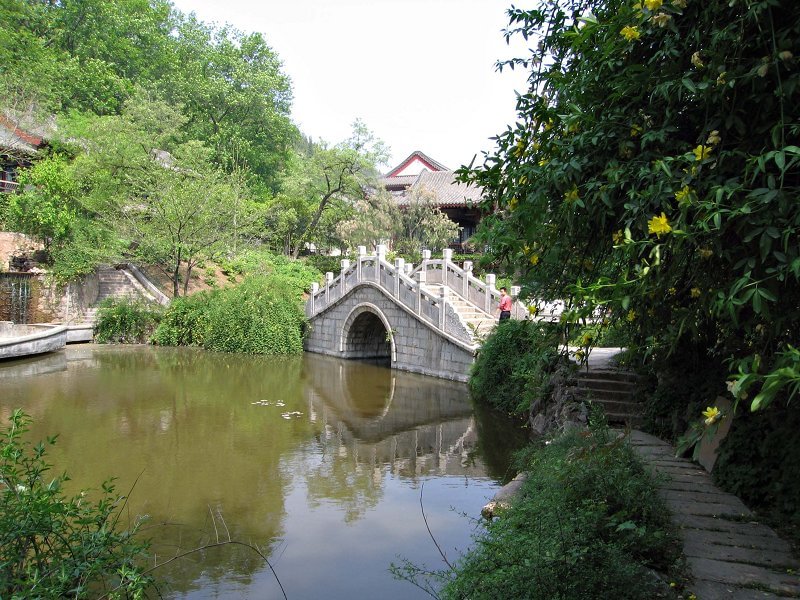
清水断崖位于苏花公路和仁至崇德之间,长约12公里的路段。其中清水山东南大断崖,绝壁临海面长达5公里,非常壮观。行于此路段,呈现眼前的险峻的残岩断壁与无垠无际的汪洋万顷,而如此惊险的路段也让人不禁缅怀拓荒者的艰辛,如同阅读山海与人之间惊心动魄的感人篇章。
同事一听说过一个女孩子,开车走苏花公路,都觉得很不安全。可,在不知不觉中,我已开车走过许多趟苏花公路。苏花公路真美…海天一色…又临山,比起一高、二高当然是不方便,但美丽的景色是无可取代的。今年农历年我还会再去喔…
景观美 但是路有点危险 选晴天走 会看到最美的苏花景色~~ 但是要小心连日下雨或地震后的落石...... 目前还没有苏花"高速"公路 所以标题是错误的唷~~
Su-hua highway is mainly a 2-lane road, narrow and twisty in places, but nevertheless wide enough for truck traffic. Saw a heavy truck overturned on one of the curves. The highway affords beautiful views of the sheer cliffs and turquoise ocean, especially around Ching-shui cliffs.
The road trip was a lovely experience of the city and provincial Taiwan passing through towns and cities. I liked the forest covered mountain and then the ocean meeting either a seashore or cliff, it is a sight to behold. There were look out points along the way and a rest area with clean toilets. There were also cheap local food to taste along way. The road though winding is safe and well paved. We also passed through several tunnels, including the Hseshan Tunnel the longest in Taiwan and one of the longest road tunnel in the world, as well as bridges. It is a truly lovely road trip.
It's a breathtaking scenery. We love the rice fields. The local shops are interesting. The people are friendly and helpful. We learned so much of local history, the so called mountain people.
Suhua Highway (蘇花公路) is the most popular, scenic, and challenging road in Taiwan, located on the east coast of Taiwan. This road starts from Suao (蘇澳) of Yilan County to Hualien City (花蓮市) of Hualien County. There are four ways that you can go from the west coast to the east coast in the north of Taiwan – air, ship, train and road. None of the other ways can compare with the breathtaking journey of the road trip. The history of the Suhua Highway can be traced back to 1874 during the Qing Dynasty where it was used for horse carriages. From 1916 to 1932, when Japanese occupied Taiwan, they renovated and broadened it several times and finally allowed cars to pass through. After WWII, government changed the name to Suhua Highway, and the name is still used today. In the beginning, some of the sections allowed only one way traffic by using the traffic control. It finally became a two-way road in 1990.The 118 kilometer-long (73.3 mi) Suhua Highway is a part of the Provincial Highway No. 9. The road was almost impossible to build due to very steep cliffs on some sections of the highway. The famous Qingshui Cliff (清水斷崖, Chingshui Cliff) is located at the southern part of the Suhua Highway. This section between Heping (和平) and Chongde tunnel (崇德隧道) covers 21 km (13 mi) of 800 m (2,625 ft) above sea level coastal cliffs. The cliffs run alongside a fault line and are comprised of marble, gneiss, and green schist. The highest peak of Qingshui Mountain is 2,408 m (7,900 ft) from the Pacific Ocean. This is the most winding and stunning section of the Suhua Highway.We started our adventure early in the morning from Taipei. My younger brother’s family and we drove 2 cars via National Highway 5 to Suao in less than 1 hour. The weather changed from sunny in Taipei to rainy in Suao. When we entered the Suhua Highway, rain started pouring down, and we could not stop at some of the stops we have planned. We were lucky the sun was coming out when we approaching Qingshui Cliff. We stopped at the 168.7 km marker where the sign of Taroko National Park (太魯閣國家公園) stands. We took some photos of the coast and the nearby natural rock arch tunnel. There was a rest area at the 171.7 km marker where we stopped for a bathroom break. Before the last tunnel, Chongde tunnel at the 176.4 km marker, there was another rest area where we saw the Qingshui Cliff and the road we passed appeared to be just a small line in the vertical precipice. At this rest area, we found the Chongde trail that can bring us to the beach. Unfortunately, the trail was damaged and closed due to the last typhoon. After the Chongde tunnel, we were only 8 km (5 mi) to the Taroko National Park. On the way back from Hualien, we visited one additional must-see stop at Huite Recreational Area (匯德休憩據點) at the 174.4 km marker. It is the old road to the old Qingshui Tunnel (清水隧道); it was abandoned due to a serious collapse. From here you also have a very good view of the beautiful coastline of the Suhua Highway. If you are taking a bus and sit on the top section of the ocean side, you will experience a very unique journey with the precarious drive between the cliffs on one side and the Pacific Ocean on the other side. That is why whenever there is a typhoon, heavy rain, or an earthquake the road will be closed due to rockslides.This well-known scenic highway is not used only for sightseeing purpose. There are many trucks which carry marble, limestone, gravel, and other industrial raw materials from east coast. It is quite a challenge to drive on this highway with those trucks and the winding road. There is an ongoing project to build a freeway based on the expansion of the existing highway. It is scheduled to complete in 2017, but delays are expected due to the unexpected weather, earthquakes, and geology conditions. The plan is to straighten wherever possible using old tunnels and to avoid the frequent rockslide and washout areas. After it is finished, the old road will be used for trucks and sightseeing while the new one will be used for pass through traffic.
We rented a car in hualien and drove down theCoast and also on the Rift Valley. It is a fantastic thing to do and I strongly recommend you rent a car since you'll see a lot of sights that are either not bus accessible or that have very infrequent service. The views towards the pacific on one side and the tall mountains on the other are unforgettable. You can find accommodation although you'll have to research a bit. Well worth it.
We hired someone to drive us from Taipei to Yi Lan, Hua Lian and then back.The scenic highway was definitely a highlight of the trip.The trip took about 4 hours each way, winding along the coast on the mountain.So will be quite dangerous if it rains and landslides are common in typhoons.However still highly recommended to include this in your trip, maybe once down south and return by train or the other way round.
We took this road on our way south to Kenting. It was a beautiful day and he scenery was just stunning. The colors you get on photos are amazing and I really don't regret not having taken the train. Road is not dangerous, just similar to a mountain road.